Friday, July 4, 2008

Western WY - Weekend on a Ranch

Starting in the fall of 1947 (that's 61 years ago!!) and for the succeeding 4-years (including a few summer schools because I was "such a good student"), I attended a boys prep school in New England - The Hotchkiss School - with some 90 classmates.

Far too few classmates I maintained close contact with; others, our relationship was refreshed at our 50th reunion. One such classmate is Hort Spitzer. He is a retired business owner who with his wife, Juli, now lives in a beautiful home in Wilson (near Jackson) WY, and owns a ranch some 80 miles to the southeast in Daniel (near Pinedale) WY. Juli is a long-time resident of the Pinedale area and maintains her own place there.

Hort and Juli hosted an evening at their Wilson home where, while having cocktails, we saw a bull moose very nearby. The weekend before the 4th of July I was their guest at the ranch.

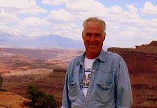
Here's Hort and Juli at Hort's ranch.
At least almost every weekend find Hort and Juli on Hort's ranch which contains some 2,000 acres bordered by 15-miles of fence. To the "city slicker" like me, the land in that region appears wild, barren and valueless - as far as the eye can see in all directions. 20-miles to the west, the endless view is arrested by the snow-capped Wyoming Range; in the distance to the north and northeast by the glacier-ridden Wind River Range. Otherwise, this apparent wasteland visually goes on forever.


However, the land is not barren. It is alive. With some very hard work it can be economically viable, as I was soon to learn.


On Hort's ranch there are two primary activities - growing grass to be harvested as hay and for grazing cattle. Harvesting the grass and ranging cattle are both cash "crops." Hort grows the grass - cattle owners lease huge areas to range their cattle, and a haying outfit comes in to harvest the grass for hay.

With Hort and his ranch hand, "Smoot," I spent the heart of a day on a super sized ATV going cross-country all over the ranch, checking on, repairing and adjusting the vast irrigation system.

Here's Smoot and the ATV. Note the wet tires which is evidence we are travelling in a well-irrigated grass area.


Water from various streams originating in the Wyoming Range course through the region including Hort's ranch. Built mainly by homesteaders in the mid-to-late 1800s, an intricate network of irrigation canals, dams and diversion channels enable spring and summer flooding of the what appears to be useless land.

The water combined with last summer's cow manure enriches the soil, enabling natural grass to grow to feed this year's grazing cattle, as well as harvesting grass/hay from 700 or so acres. This past winter was a big snow year and abundant water courses and saturates the ground - virtually everywhere we drive.

Any areas not getting appropriate amounts of water cause us to stop and Hort and Smoot to adjust the diversion dams and culverts, as well as checking for and destroying beaver dams. My job was to open and close fence gates, take pictures, and ask a million questions.

Here you see Hort installing a diversion dam made of plastic coated canvas. The dam causes water to overflow the irrigation ditch and spread out over the grass areas on both sides.


On an adjacent ranch are original homesteader cabins and, up on the hill in the first photo following - a proverbial one-room school house. The schoolhouse was built in 1901 and operated continuously until after the WWII period. Hort pointed out that it was obvious the last cabin inhabitants had vacated abruptly as we saw many items left behind, including a shirt hanging on a hook (which I failed to photograph!).


Here you see Hort and me standing in front of a device used to manually create haystacks in the "olden days" before machinery.


Driving back to my portable home in the Jackson Hole WY area, I took the "back road way." 20 miles to the west of the ranch along an undulating dirt road, seeing Antelope and free-ranging cattle, abruptly the Wyoming Range juts upwards.

One begins the climb up to and over McDougal Gap near 11,134 ft Lander Peak, descending to near the headwaters of the Grey's River which drains the canyon northward between the Wyoming Range and the Salt River Range which parallels and is just west of the Wyoming Range.

VERY remote, stunningly rugged glaciated cirques and valleys, and contorted geological formations are a feast to to one's visual senses. The Grey's River is at flood stage, draining into the Snake River. Sorry - no photos!!

Here you see free-ranging cattle, the Grey's River and 10,103 ft Stewart Peak at the north end of the Salt River Range and nearing the "town" of Alpine WY. Alpine is the point where the Grey's River joins the Snake River, which in turn turns west into Idaho to continue its circuitous route to the Columbia River and finally the Pacific Ocean.

Monday, June 23, 2008

Grand Teton National Park/Jackson Hole WY

It's been far too long since my last post! Readers are "begging" for an update on my experiences and a new entry!! So - let's see what shows up!

The Moab and Canyonlands and Arches National Parks in the southeastern Utah area is one of my favorites. Easy/moderate hiking and biking, a day with Ara and Spirit (see previous post), and Jeeping in the Island In the Sky area of Canyonlands with RV caravanning friends, the Skinnels and their dog, BJ, kept me "off the streets" and a very "happy camper" during the first part of May.

This photo is of the Shafer Trail which switchbacks abruptly up over 1,000 feet from the lower mesa overlooking the Colorado River to the rim of Island in the Sky region of Canyonlands.


This photo of Corona Arch in Canyonlands at the end of an hour's hike.

In mid-May, moved up to Salt Lake City (my last permanent residence area and where I lived for 20-years), spending a busy month there and in Park City and Oakley making new and enjoying old friends, persevering through the semi-annual doctor and dentist visits and coach maintenance, and stocking up for the summer's portable living.

Lots of hiking and biking in Park City area, as well as biking along the Jordan River Parkway in the Salt Lake City valley. Over the past 3-months or so, have lost 20 pounds and blood pressure is way down -- I feel much spryer!

While I am familiar with and comfortable in the greater Salt Lake City area and can't have a better place to roost (friends - Turnquist's RV Resort), I prefer being in less congested, noisy and environmentally challenged areas. Am a fortunate guy to have the choice and a comfortable portable home to make it practical!

So, late last week, onward north to Jackson Hole WY/Grand Teton National Park area where, at about 6,500 ft. altitude in the Hole, spring is still very present with summer looming (low 40's in the early morning, and mid-to-high 70's during the day). This winter saw abundant snow and spring was wet and colder than normal. The Snake and Gros Ventre Rivers are in spring runoff flood stage.

Next photo is of my portable home and view of the Grand Tetons from my campsite in Gros Ventre National Park Campground. Pretty AWESOME!!

River-runners (and the businesses which provide the thrills) are in seventh-heaven. Here you see a raft going through the "Lunch Counter" rapids on the Snake River, which is at flood-stage.

Here are happy and wet recent river-runners, hiking up to waiting busses to take them home.

Here you see me trying out a demo kayak in Lower Slide Lake on the Gros Ventre River - "only $2,000 and it's yours," said the salesman. By the way - I did not run the rapids!!

Wild flowers are everywhere and the Jackson Hole and surrounding region's landscape is totally green. The Grand Teton and the Gros Ventre Ranges provide snow-capped backdrops.

Even the free-ranging Bison are content - resting in the wildflowers and soaking up nature's grandure in this vast and - for them - protected region.

Everywhere near the Tetons, in the town of Jackson, and up towards and into Yellowstone are increasing numbers of bicyclists, motorcyclists, tourists (Americans and foreigners) in cars, in rented RVs or their own RVs and others arriving by air at the seasonally very busy airport.

The Gros Ventre National Park campground 12 miles northeast of Jackson where I am esconced is not busy - yet. It is huge - 350 sites - quiet and serene adjacent to the cresting Gros Ventre River.

Hiking, biking, Jeeping, wild-life viewing, attending concerts, the Bar J Wranglers and hot-air balloon events, and preparing for and enjoying visits by friends here in this magnificient region likely will keep me out of mischief until July 21 when I'll return to Salt Lake City, put coach in storage and fly back to New England to visit my two sons and their families, as well as old and treasured friends until after Labor Day.

Friday, May 9, 2008

A Day with Ara & Spirit

Note to Readers: If you want to enlarge any photo, double click on the photo. When ready to return to the blog entry, click the "return" left arrow in your screen's upper left corner.

There is a very fine landscape and geologic/nature photographer, Ara Gureghian, who with his companion, Spirit - now a gentle Pit Bull rescued by Ara 3-years ago after a life of abuse and about to be put away, are full-time vagabonds. Here's Ara following his snapping some photos. And Spirit.

Check Ara & Spirit's blog site http://theoasisofmysoul.com/ to read about their adventures and see examples of Ara's awesome photography and read of his view of life and experiences. Be sure to peruse the archives section of his blog - you will not be disappointed!! Here's a photo of the master photographer with the volcanic La Sal Mountains behind.

For many years before adopting the RV lifestyle, Ara soloed in a sailboat. He is reported to be an excellent chef/cook and now works occasionally wherever he finds an opportunity to delight appreciative diners.

Ara and Spirit are inseparable, living in a RV Class C portable home and towing a trailer upon which is transported their BMW motorcycle/side car, which they use to see the local sights, etc., just as I do in my Jeep Liberty. In the sidecar rides Spirit, complete with doggels and a helmet.

RV caravanning friends, Landon & Marcella Skinnell and their Beagle, BJ, and I had a very good day with Ara and Spirit together in Moab, Utah, riding what is called the La Sal Mountain Loop drive - a 100-mile drive out of Moab, up through red rock/desert conditions, to the lava covered flanks of the still snow-covered peaks of the La Sal Mountains. The westward view from along the flanks is out over and down into Canyonlands and Arches National Parks. Here's Ara photoing his BMW which has a snowman on the front of the sidecar.

As one proceeds from south to north up to and after traversing the flank, you enter Castle Valley where the Priest and Rectory/Nuns and Fisher Towers features become so prominent and magnificient.

Each time when visiting this area, I drive the Loop. Passing by the Priest and Rectory/Nuns area, I recall being with my youngest son, Bruce, (me awaiting at the bottom) as he and a climbing buddy summited the Priest. Recently, I received a report of the sucessful summiting of Sister Superior, one of the Rectory/Nuns, by a close friend of Bruce's. This photo includes Ara, Landon and the Priest and Rectory/Nuns. Sister Superior is at the left.

Monday, May 5, 2008

Wilderness of Rock - Part 1

The latter part of March and all of April found me in Prescott, Arizona. At 5,000 ft and with winter lingering, it was abnormally cold and windy. Notwithstanding, almost daily found me hiking and out in my Jeep with new-found friends, exploring and experiencing the area, including Crown King and Jerome, ledgendary mining towns.

Prescott is on the southern edge of the Colorado Plateau - a vast region stretching from the Rocky Mountains in Colorado west into Utah, southwest into Arizona, and northern New Mexico. The region is often referred to as the 4-Corners area - the conflence of 4 states - Colorado, New Mexico, Arizona and Utah. While there is some green and trees at highest elevations, much of the topology is rocky and seemingly barren.

Many millions of years ago, variously lava, ancient seas, and material eroded from the then much, much higher Rocky Mountains accumulated in layers and solidified into primarily sedimentary rock - in places 15,000 feet thick. Then, a force within the earth caused the entire region to rise, creating what is called the Colorado Plateau.

While the land mass rose, the existing rivers flowing from the east (primarily the Colorado and San Juan Rivers) and north (predominately the Green River) carved into the surface faster than the land mass rose, causing today's Grand Canyon and many, many other canyons and geologic features. Add in rain, snow and wind and what we see today is the fantastic result. Here is the San Juan River on its way west to join the Colorado River and Lake Powell.

Thus, the title of this blog entry - "Wilderness of Rock."

After weeks in the Prescott area including a visit with oldest son, Steve, and his family when they vacationed in Tucson area, with new RV friends, Landon and Marcella Skinnell and their Beagle, BJ, moved north to Flagstaff Arizona.

Flagstaff is at 7,000 ft and near the volcanic San Francisco Peaks, including Humphreys Peak, the highest point in Arizona at 12,643 ft.

About 1,060 A.D. and over about a 200-year period, the San Francisco Mountains (then much higher) started erupting/exploding, spewing lava and ash in an 800 square mile region, primarily to the east of the mountains. We Jeeped into this area named Sunset Crater.

Also, we visited a nearby, partially restored, multi-level "high-rise", 100-room pueblo, called Wupatki Pueblo. It was built and inhabited after the eruptions ceased. Inhabitants irrigated, farmed and traded -- before abandoning everything after about 100-years.

Caravanning with the Skinnell's, we moved further north through the western part of the Navaho Nation in northeastern Arizona to Monument Valley, which is partly in southeastern Utah. Words cannot describe and photos simply do not provide visual completeness or feeling to the stunning, raw topography one experiences. As the light changes, the scene changes. Sunrise and sunset are when the colors are most vivid and features are "etched."

On northward to Valley of the Gods in southeastern Utah which is a mini-Monument Valley and where, with the Skinnell's parked nearby, I drycamped (boondocked). Out the RV's front window are simply stunning views looking south to Monument Valley in the far distance! Right next to our coaches was this awe-inspiring sight!

Nearby, the San Juan River flows westward towards the Colorado River and Lake Powell. At Gooseneck Overlook, one sees the result of its relentless erosion of the Colorado Plateau as it carved down throuh the many layers of rock faster than the Plateau rose.

Monday, March 24, 2008

The Town Too Tough To Die - Tombstone

It's 1877 -- 121 years ago. Imagine you are Ed Schieffelin, a prospector visiting in the area of Camp (now, Fort) Huachuca in the east-facing foothills and flanks of the Huachuca Mountains in southeastern Arizona. Looking across the San Pedro River Valley to the east, you see a low mountain range which you think to be a promising source of silver. Undaunted by the ever-present Apaches who continuously tried to rid their homeland of the white man and warned by Camp Huachuca's Indian-fighter soldiers that the only thing you'll find would be your tombstone, you find a very rich silver strike, naming your first claim, "Tombstone," and another "Graveyard." Word spread quickly of the silver discovery and fabulous yields. More a prospector than a miner, Ed profitably sold his claims and moved on to prospect in the Klondike. He is buried in Tombstone.

By 1883, Tombstone was a booming mine town of 7,000 with an impressive infrastructure in place (including 110 saloons and numerous gambling houses and bordellos/cribs).In 1883, incredibly, a 36-mile underground 15-inch pipeline was constructed from the Huachuca Mountains across the San Pedro River Valley and under the river to provide water for the residents and mining operations. Today, it remains Tombstone's water supply!For about 100-years, Tombstone's mines have been closed (ground water flooded them) and the town is nothing more or less than an attractive tourist attraction. The residents, businesses and government have collaborated variously to restore, preserve and replace with replicas what Tombstone was in the late 1800s and early 1900s.

Residents dress in period costumes and mingle with the tourists along Allen Street which is lined with boardwalk-like sidewalks and is blocked from vehicles except horse-drawn carriages and wagons carrying tourists. Saloon bouncers, gunslingers and reprebates roam the streets. Gunfights (using blanks!!) randomly breakout or are carefully staged (for an addmission fee of course). Tourists (and I) love it!! Original and restored bars and tours of bordellos (no live ladies apparent when I'm there!) do a lively business. Merchants must do OK as, year-after-year, I see the same ones happily relieving tourists of their $.

The courthouse is the original 1802 building and was the Chochise AZ County seat (now, it's in Bisbee to the south). Within are wonderful displays of period artifacts and history of Tombstone and its famous and infamous inhabitants. Near downtown Tombstone is Boot Hill. Good fun seeing the headstones of some of the town's colorful residents. Ore from Tombstone's mines was transported 10-or-so miles by wagon trains to Fairbanks and Charleston, respectively a railhead and a smelter. Those support towns next to the San Pedro River grew like weeds and flourished -- or became ghost towns -- based upon the health of Tombstone and productivity its mines. In 1882, Fairbanks had a larger population than San Francisco!