Friday, May 9, 2008

A Day with Ara & Spirit

Note to Readers: If you want to enlarge any photo, double click on the photo. When ready to return to the blog entry, click the "return" left arrow in your screen's upper left corner.

There is a very fine landscape and geologic/nature photographer, Ara Gureghian, who with his companion, Spirit - now a gentle Pit Bull rescued by Ara 3-years ago after a life of abuse and about to be put away, are full-time vagabonds. Here's Ara following his snapping some photos. And Spirit.

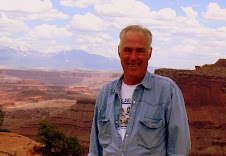
Check Ara & Spirit's blog site http://theoasisofmysoul.com/ to read about their adventures and see examples of Ara's awesome photography and read of his view of life and experiences. Be sure to peruse the archives section of his blog - you will not be disappointed!! Here's a photo of the master photographer with the volcanic La Sal Mountains behind.

For many years before adopting the RV lifestyle, Ara soloed in a sailboat. He is reported to be an excellent chef/cook and now works occasionally wherever he finds an opportunity to delight appreciative diners.

Ara and Spirit are inseparable, living in a RV Class C portable home and towing a trailer upon which is transported their BMW motorcycle/side car, which they use to see the local sights, etc., just as I do in my Jeep Liberty. In the sidecar rides Spirit, complete with doggels and a helmet.

RV caravanning friends, Landon & Marcella Skinnell and their Beagle, BJ, and I had a very good day with Ara and Spirit together in Moab, Utah, riding what is called the La Sal Mountain Loop drive - a 100-mile drive out of Moab, up through red rock/desert conditions, to the lava covered flanks of the still snow-covered peaks of the La Sal Mountains. The westward view from along the flanks is out over and down into Canyonlands and Arches National Parks. Here's Ara photoing his BMW which has a snowman on the front of the sidecar.

As one proceeds from south to north up to and after traversing the flank, you enter Castle Valley where the Priest and Rectory/Nuns and Fisher Towers features become so prominent and magnificient.

Each time when visiting this area, I drive the Loop. Passing by the Priest and Rectory/Nuns area, I recall being with my youngest son, Bruce, (me awaiting at the bottom) as he and a climbing buddy summited the Priest. Recently, I received a report of the sucessful summiting of Sister Superior, one of the Rectory/Nuns, by a close friend of Bruce's. This photo includes Ara, Landon and the Priest and Rectory/Nuns. Sister Superior is at the left.

Monday, May 5, 2008

Wilderness of Rock - Part 1

The latter part of March and all of April found me in Prescott, Arizona. At 5,000 ft and with winter lingering, it was abnormally cold and windy. Notwithstanding, almost daily found me hiking and out in my Jeep with new-found friends, exploring and experiencing the area, including Crown King and Jerome, ledgendary mining towns.

Prescott is on the southern edge of the Colorado Plateau - a vast region stretching from the Rocky Mountains in Colorado west into Utah, southwest into Arizona, and northern New Mexico. The region is often referred to as the 4-Corners area - the conflence of 4 states - Colorado, New Mexico, Arizona and Utah. While there is some green and trees at highest elevations, much of the topology is rocky and seemingly barren.

Many millions of years ago, variously lava, ancient seas, and material eroded from the then much, much higher Rocky Mountains accumulated in layers and solidified into primarily sedimentary rock - in places 15,000 feet thick. Then, a force within the earth caused the entire region to rise, creating what is called the Colorado Plateau.

While the land mass rose, the existing rivers flowing from the east (primarily the Colorado and San Juan Rivers) and north (predominately the Green River) carved into the surface faster than the land mass rose, causing today's Grand Canyon and many, many other canyons and geologic features. Add in rain, snow and wind and what we see today is the fantastic result. Here is the San Juan River on its way west to join the Colorado River and Lake Powell.

Thus, the title of this blog entry - "Wilderness of Rock."

After weeks in the Prescott area including a visit with oldest son, Steve, and his family when they vacationed in Tucson area, with new RV friends, Landon and Marcella Skinnell and their Beagle, BJ, moved north to Flagstaff Arizona.

Flagstaff is at 7,000 ft and near the volcanic San Francisco Peaks, including Humphreys Peak, the highest point in Arizona at 12,643 ft.

About 1,060 A.D. and over about a 200-year period, the San Francisco Mountains (then much higher) started erupting/exploding, spewing lava and ash in an 800 square mile region, primarily to the east of the mountains. We Jeeped into this area named Sunset Crater.

Also, we visited a nearby, partially restored, multi-level "high-rise", 100-room pueblo, called Wupatki Pueblo. It was built and inhabited after the eruptions ceased. Inhabitants irrigated, farmed and traded -- before abandoning everything after about 100-years.

Caravanning with the Skinnell's, we moved further north through the western part of the Navaho Nation in northeastern Arizona to Monument Valley, which is partly in southeastern Utah. Words cannot describe and photos simply do not provide visual completeness or feeling to the stunning, raw topography one experiences. As the light changes, the scene changes. Sunrise and sunset are when the colors are most vivid and features are "etched."

On northward to Valley of the Gods in southeastern Utah which is a mini-Monument Valley and where, with the Skinnell's parked nearby, I drycamped (boondocked). Out the RV's front window are simply stunning views looking south to Monument Valley in the far distance! Right next to our coaches was this awe-inspiring sight!

Nearby, the San Juan River flows westward towards the Colorado River and Lake Powell. At Gooseneck Overlook, one sees the result of its relentless erosion of the Colorado Plateau as it carved down throuh the many layers of rock faster than the Plateau rose.